


Valley Metro
4.61.28K Reviews
App Specs
- Version
- 3.3.0
- Updated On
- License
- Free
- Downloads
- 100,000+
- Developer
- ValleyMetro
- Categories
- Maps & Navigation
- Platform
- Android, iOS
Screenshots
 Analysis by AppCompare
Getting around the Phoenix metro area by public transportation is much easier when the information is organized around the trip you actually need to make. Valley Metro is the official transit app from ValleyMetro, and after using it as a practical travel tool, I found that its main appeal is focus: it is built for people planning journeys on the local network rather than for general map browsing. It is a free Maps & Navigation app, rated for Everyone, and its current version is 3.3.0.
I would not describe it as a replacement for every navigation app on a phone. Instead, I see it as a local companion for checking a transit journey in the metro Phoenix area, especially when walking, driving, or ride-hailing is not the whole answer. The useful question is not whether it has more features than a broad mapping service, but whether its local transit focus makes your daily trip clearer and less stressful.
What Valley Metro is really useful for
The app’s strongest role is helping a rider think in terms of a complete public-transport trip. That means the useful result is not simply a line on a map. You need to know where to begin, which service to use, where to change direction or mode if necessary, and how to finish the walk at the destination. A dedicated Valley Metro tool makes that local context the center of the experience.
That focus matters in a large metropolitan area. A general map app may show several ways to reach a place, but it can also place driving, walking, cycling, and transit choices beside one another. Valley Metro is more appropriate when the first decision has already been made: I want to use the local transit network, and I need the app to help me make sense of that choice.
In everyday use, I would open it before leaving rather than waiting until I am already standing at a stop. I can check the route, look at the sequence of the journey, and notice whether the trip requires extra walking or a transfer. That small preparation is valuable in Phoenix, where a seemingly short walk can feel very different depending on the time of day and the weather.
The app is also easier to judge when you separate trip planning from general orientation. For discovering restaurants, comparing businesses, or deciding where to stop along the way, a broad map service remains more versatile. For understanding a Valley Metro journey, the dedicated app has a more sensible starting point because it keeps the transit network in view.
A realistic morning trip
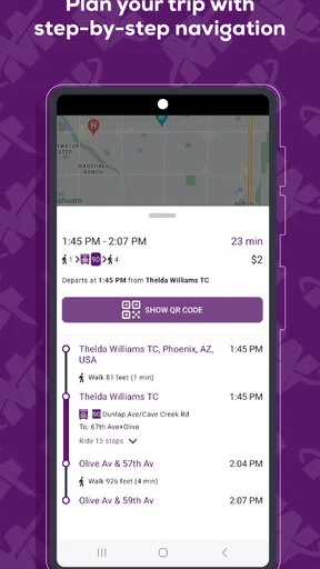
Imagine I am leaving home for an appointment and want to avoid driving into a busy area. I would enter the starting point and destination, then inspect the suggested journey rather than accepting it blindly. I would pay attention to the first walking segment, the transfer point, and the final approach to the destination. If the route looks awkward, I would compare another departure or a different connection before stepping outside.
Worth Reading Before You Choose

EA SPORTS FC Mobile 26 Is a Bigger Football Game, but It Takes Time

Flipboard Shows What News Apps Must Do Beyond the Feed

Switching to Android Auto Means Rethinking Your Driving Routine

Google Calendar Makes a Crowded Week Easier to Manage

Ludo King Makes the Most of the Minutes Between Plans

Baby Panda World Brings Quick Play to Modern Phones, but Its Game Library Feels Busy
That workflow is more useful than simply asking whether the app “has directions.” Transit directions are only as good as the rider’s understanding of the handoffs between walking and transit. My practical tip is to read the journey from both ends: first check how you reach the service, then check how you leave it. The final walk is easy to ignore when the transit portion looks straightforward.
For a visitor, this can reduce the learning curve around the local system. For a regular rider, it can be a quick confirmation before leaving. I would still build in extra time for walking, finding the correct boarding area, and dealing with an unfamiliar transfer. An app can organize the trip, but it cannot remove every real-world uncertainty at the curb.
Cost and the value of a focused local tool
Valley Metro is free to download and use as an app. That gives it a clear advantage for someone who wants a dedicated transit reference without committing to a subscription or a separate purchase. The free price also makes it easy to keep alongside a general maps app instead of forcing an either-or decision.
There is an important distinction here: free access to the app is not the same thing as free transportation. The app helps with planning a trip, but it should not be read as making the underlying journey cost nothing. I value it for reducing planning friction, not for changing the cost of riding.
Its value is highest when I use public transportation often enough that small bits of uncertainty add up. A commuter, student, visitor, or occasional rider who dislikes guessing at connections can get practical value from having the local network in one place. Someone who drives everywhere and only needs directions a few times a year may find a general navigation app sufficient.
The adoption figures suggest that it has reached a meaningful local audience: it has more than one hundred thousand installs, with a 4.6 average from roughly twelve thousand ratings and about one thousand three hundred written reviews. I treat that as useful context rather than proof that every rider will have the same experience. A local transit app can be well regarded and still be a poor fit for someone whose journeys rarely involve Valley Metro.
Where it fits beside the usual alternatives
My usual alternative would be a broad mapping app. That option is better when I am comparing transit with driving, searching for a business, checking an exact walking entrance, or combining several kinds of transportation in one plan. It is also the more convenient choice when my trip is not centered on the Phoenix metro network.
Valley Metro becomes more attractive when I want a local transit-first view. The narrower scope is not automatically a weakness. It can prevent the transit option from being buried beneath driving routes and unrelated map results. The trade-off is that I should not expect one specialized tool to replace the wider location search, business information, and flexible route comparisons I get elsewhere.
For a visitor already using a general map service, I would use both rather than immediately abandoning one. I would use Valley Metro to understand the public-transport portion, then use the broader map for the destination entrance or nearby landmarks. This two-app workflow sounds less elegant, but it is often more dependable than expecting a single app to be perfect at local transit and general geography at the same time.
Small habits that make the app more useful
My first habit would be to plan from the actual starting point, not merely from the nearest named landmark. The difference between a home, hotel, office, or parking area and the closest transit stop can change the whole experience. Starting too broadly can make a route look simple while hiding a long first walk.
Second, I would inspect transfers as separate tasks. A transfer is not just a line in a route summary; it is a moment when I need to know whether I have enough time, whether I understand the direction, and whether the next boarding location is obvious. When I am unfamiliar with the area, I would save the route details mentally before leaving rather than relying on constant screen checking.
Third, I would use the app as a decision tool before the journey, not only as a rescue tool after something goes wrong. Checking alternatives early gives me a chance to choose a less complicated trip. Waiting until I have missed a connection usually leaves fewer choices and makes the same app feel more stressful than it needs to be.
A fourth useful habit is to compare the app’s transit plan with the physical reality around the destination. A route can be sensible on a network diagram while the last stretch still requires careful attention. I would confirm the street side, identify a visible destination landmark, and keep enough battery available for the final part of the trip. Those are simple steps, but they address the gap between digital planning and being outdoors.
The limitations I would keep in mind
The biggest limitation is scope. Valley Metro is designed for the metro Phoenix transit area, so it is not the right everyday planner for someone whose travel is mostly outside that network. If I need nationwide trip planning, international coverage, detailed business discovery, or a single app for many transport providers, a broader service will be more useful.
The local focus can also create a different kind of friction. A dedicated transit app may answer the transit question well while leaving other parts of the outing to another tool. I should be prepared to switch apps for a restaurant, a precise building entrance, a driving detour, or a walking route that extends beyond the transit journey.
I also would not treat any planned departure as a guarantee. Real trips involve weather, crowds, construction, missed connections, and changes in personal pace. The app can help me choose and understand a route, but I still need a little flexibility. My practical rule is to check the journey before leaving and then allow extra time whenever the appointment is important.
Another trade-off is that a transit-first experience may feel unnecessary for a rider who already knows the network by heart. If I take the same journey every day and never need to compare options, opening an app can add a step rather than remove one. In that situation, the app’s value comes back when the destination, departure time, or connection changes.
Who will get the most from it?
I think Valley Metro is a strong fit for Phoenix-area residents who use buses or rail often enough to benefit from a dedicated reference. It is also a sensible download for visitors who plan to rely on public transportation and want something centered on the local system. Because it is free and rated for Everyone, the barrier to trying it is low.
It may be particularly helpful for someone who is comfortable using a phone but not yet comfortable interpreting transit routes. The app gives that person a place to begin, while repeated use can make the local network feel less intimidating. I would recommend testing a route on a non-urgent trip first, so the rider learns how the app presents the journey without the pressure of an appointment.
People who should skip it are those looking for a universal navigation solution, those who rarely travel in the metro Phoenix area, and those who need detailed coverage beyond local transit planning. A general maps app will be the better first download for them. I would also skip relying on it alone for a complicated day involving several unrelated stops, because a broader planner may handle the complete outing more conveniently.
For families or groups, I would use it to agree on the overall route before leaving, then discuss the walking portions and meeting points separately. That is more practical than passing one phone around while everyone is already moving. For a solo rider, the same preparation can make transfers calmer and reduce the temptation to make route decisions while distracted.
My verdict on downloading Valley Metro
After weighing the free access against its focused scope, I see Valley Metro as a worthwhile local utility rather than an all-purpose navigation replacement. Its value comes from making public-transport planning in the metro Phoenix area the main task, which is exactly what many riders need. The app is developed by ValleyMetro, was released on June 29, 2021, and has continued to a current version of 3.3.0, giving it the profile of an established local tool rather than a one-off experiment.
I recommend downloading it if your trips regularly depend on Valley Metro services. The price makes trying it an easy decision, and the local emphasis can save time when a general map leaves transit details feeling secondary. I would pair it with a broader map when I need business searches, exact destination entrances, or other transportation modes.
I would not install it expecting a complete replacement for every navigation need. Its best use is narrower and more practical: plan the transit journey, inspect the walking and transfer points, and leave with a realistic idea of what the trip involves. Used that way, it delivers good value without pretending to solve problems outside its purpose.
My final recommendation is simple: if you live in or are visiting the Phoenix metro area and want to use public transportation, give it a try before an important trip. If you rarely use local transit or need broad travel planning, keep your usual map app instead. For the right rider, this free local companion earns its place by making Valley Metro journeys easier to understand, not by trying to be everything on the phone.
Pros
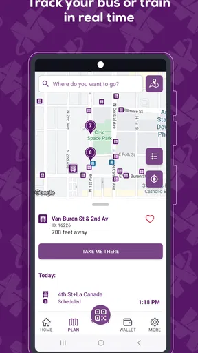
- Real-time bus and rail arrival information helps reduce waiting uncertainty.
- Trip planning combines Valley Metro routes with walking directions.
- Service alerts highlight delays
- closures
- and route changes.
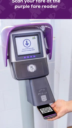
- Mobile ticketing can make boarding quicker on eligible services.
- Maps and schedules are useful for exploring the Phoenix metro area.
Cons
- Arrival predictions may become inaccurate during heavy traffic or disruptions.
- Some app features depend on a stable internet or GPS connection.
- Coverage is limited to the Valley Metro service area.
- Ticket options and fares may vary by route
- requiring careful selection.
- The interface can feel less intuitive for first-time public transit users.
FAQs for Valley Metro
What is Valley Metro, and what can I use the app for?
Valley Metro is a public transportation app for planning and managing trips across the Phoenix metropolitan area. After installing it, you can look up bus and light rail routes, check schedules, find nearby stops and stations, view service information, and organize journeys using available transit options. It is especially useful for commuters, students, visitors, and anyone who wants current transportation details before leaving.
Does Valley Metro provide real-time arrival information?
Yes, Valley Metro can provide arrival and departure information for participating bus and light rail services, helping you estimate when a vehicle should reach your selected stop or station. However, real-time predictions may occasionally be delayed or unavailable because of traffic, technical problems, GPS limitations, or service disruptions. It is still a good idea to arrive a few minutes early, particularly for important appointments.
Can I use Valley Metro to plan a complete trip?
The app is designed to help users plan journeys by combining route, stop, schedule, and service information. Depending on your starting point, destination, travel time, and available transit connections, it can help identify suitable buses or light rail services. Before confirming your trip, review walking directions, transfer points, departure times, and any alerts, since construction or temporary changes can affect the suggested route.
Does Valley Metro support fares, passes, or mobile ticket purchases?
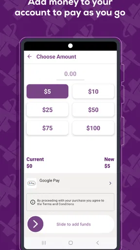
Valley Metro may include information about fares, passes, payment options, and applicable transit products, but the exact purchasing features can depend on the service version, location, and current regional ticketing arrangements. Before relying on the app as your only ticket, check whether your preferred fare can be bought or displayed directly through it. Keep an alternative payment method available when traveling.
Does Valley Metro work without an internet connection?
Some previously loaded information, such as saved details or recently viewed schedules, may remain accessible temporarily, but the app generally benefits from an active internet connection. Live arrivals, updated disruptions, trip planning, and current schedules require fresh data and may not work correctly offline. For reliable use, open the app before traveling, check your route while connected, and save important information in advance.


